
Science and Discovery –
Geologic History
Crater Lake National Park has a fascinating history. Created by the explosion of Mt. Mazama 7,700 years ago, Crater Lake has long inspired reverence and wonder. Here’s a brief explanation how it all took place.
Formation
Crater Lake sits atop Mount Mazama, a Quaternary volcano that is part of the Western Cascade Range, active about 2.5 millions years ago to the present day. Mazama began to form a half million years ago. 42,000 years ago it stood at its tallest height at 12,000 feet.
Eruption
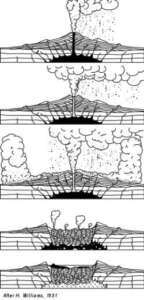
Mazama had its most destructive eruption about 7,700 years ago, spewing 12 cubic miles of rhyolite magma (gas rich, erupting explosively, forming a frothy solidified magma called pumice) in the form of tephra as far north as Alberta, Canada, as far east as Wyoming and as far south as Nevada and northern California. Pyroclastic flows and lahars descended down around the volcano and a thick layer of tuff formed on the landscape and can still be seen today.
Collapse
As a result of the eruption, Mazama lost enough material that the weight of the peak of the volcano could not be supported and it collapsed upon itself, creating a caldera.
Wizard Island
Mazama continued to have smaller eruptions, which sealed the caldera floor and created a cinder cone within the caldera which is now called Wizard Island.
Formation of the Lake
Over 700 to 1500 years, rain and snow melt gradually filled the caldera, forming Crater Lake. Today, there is a balance between evaporation and precipitation and the water level in the lake usually fluctuates less than three feet year to year.
Human Activity
In terms of geologic time, Crater Lake is very young. It is believed that humans likely witnessed the explosion. In fact, a sandal was found buried in the ash from the eruption. Klamath tribes have legends of how Crater Lake came to be.
Science and Discovery –
Geologic History
Crater Lake National Park has a fascinating history. Created by the explosion of Mt. Mazama 7,700 years ago, Crater Lake has long inspired reverence and wonder. Here’s a brief explanation how it all took place.
Formation
Crater Lake sits atop Mount Mazama, a Quaternary volcano that is part of the Western Cascade Range. Mazama began to form a half million years ago. 42,000 years ago it stood at its tallest height at 12,000 feet.
Eruption
Mazama had its most destructive eruption about 7,700 years ago, spewing 12 cubic miles of rhyolite magma in the form of tephra as far north as Alberta, Canada, as far east as Wyoming and as far south as Nevada and northern California. Pyroclastic flows and lahars descended down around the volcano and a thick layer of tuff formed on the landscape and can still be seen today.
Collapse
As a result of the eruption, Mazama lost enough material that the weight of the peak of the volcano could not be supported and it collapsed upon itself, creating a caldera.
Wizard Island
Mazama continued to have smaller eruptions, which sealed the caldera floor and created a cinder cone within the caldera which is know called Wizard Island.
Formation of the Lake
Over 700 to 1500 years, rain and snow melt gradually filled the caldera, forming Crater Lake. Today, there is a balance between evaporation and precipitation and the water level in the lake usually fluctuates less than three feet year to year.
Human Activity
In terms of geologic time, Crater Lake is very young. It is believed that humans likely witnessed the explosion. In fact, a sandal was found buried in the ash from the eruption. Klamath tribes have legends of how Crater Lake came to be.
")
Science and Discovery –
Crayfish Threatens Lake's Newt
Found only in Crater Lake, the Mazama newt was once the top of the lake’s food chain. Today it is threatened by invading crayfish originally introduced to the lake as a food for fish. Read more and see more in a video produced by Oregon Public Broadcasting.
Science and Discovery –
Crayfish Threatens Lake's Newt
The Mazama newt, once the top of the lake’s food chain, is threatened by invading crayfish. Read, watch or listen to this OPB report.

Why Support the Crater Lake National Park Trust?
A Great Place for Families
Crater Lake is spectacular. Blue, blue, blue is all I have to say. The views from anywhere in the park are breathtaking. Just a great place for hiking, and taking in the views. Lots of different options for trail hiking, from easy to challenging. Great place for families.
Science and Discovery –
Birds
A variety of birds visit and live in Crater Lake National Park. Read about the crucial role Crater Lake has played in the resurgence of the Peregrine Falcon population in Oregon here.
Crater Lake also has a nesting pair of Bald Eagles. Thanks to safe habitats such as Crater Lake, Bald Eagles were de-listed from the Endangered Species Act in early Summer of 2007. The birds are not a common site at the park, but you can see the eagles within the Klamath Basin Refuge.
The most abundant birds in the park are the Clark’s Nutcracker, Mountain Chickadee, and the Dark-eyed Junco. For a complete list of birds found in the park visit the Crater Lake National Park archives.
")
Science and Discovery –
Science and Learning Center
Opened in 2005, the Crater Lake Trust helped create the Science and Learning Center in two historic Park Buildings.
The Center offers offices, library space, and overnight lodging for researchers in the Park.
Science and Discovery –
Science and Learning Center
The Trust helped create a Science and Learning Center, which opened in 2006 in two historic Park buildings.
The Center offers offices, library space, and overnight lodging for researchers in the Park.

Why Support the Crater Lake National Park Trust?
It is Truly Amazing
What an amazing place and experience. Like no other park I’ve been too. As with all the other national parks, it is truly amazing. Go and enjoy on a full moon weekend and go for a walk at night from the lodge. Then do the full drive around. Go in the shoulder season and hope for some snow. It gets cold and windy but is beautiful.
Science and Discovery –
Bathymetry
Crater Lake’s bathymetry, or water depth, was studied in detail by a research boat airlifted into Crater Lake in 2000. Scientists from the U.S. Geological Survey, the University of New Hampshire, and the National Park Service studied the lake bottom in depth and produced a wealth of data.

Science and Discovery –
Geographic Data
Several government agencies have partnered to develop databases of GIS (geographic information service) data about Crater Lake, which is available free for download.
Science and Discovery –
Geographic Data
Several government agencies have partnered to develop databases of GIS (geographic information service) data about Crater Lake, which is available free for download.

Why Support the Crater Lake National Park Trust?
Awe Inspiring
Crater lake was awe-inspiring. I definitely recommend the boat tour. The hike down and back up from the boat is definitely worth it. The water is unbelievably blue. It looks like they dye it that color. The rangers are very friendly and willing to answer questions.
Science and Discovery –
Geologic History
Geologic Features
There are many remarkable geologic features within Crater Lake National Park. The main forces that created the formations around the park were volcanic activity and glaciers. The steep walls of the caldera in which Crater Lake rests allow for a clear view of the layers of volcanic ash that built up with multiple eruptions, including the eruption that allowed for the formation of Crater Lake
Cloudcap
Cloudcap offers stunning views of the lake from its pumice covered cliff. It is similar but older than Llao rock; both are formed of rhyodacite lava that filled an old explosion crater. Cloudcap erupted 20,000 to 30,000 years ago.
Devils Backbone
This jagged dark rock band runs from the rim down to Crater Lake. Devils Backbone formed when lava seeped up through a crack in the mountain and cooled. Over thousands of years, the softer rock around the lava eroded leaving the feature exposed.
Garfield Peak
Named after James Garfield the Secretary of State under Roosevelt and the first cabinet member to visit Crater Lake after it became a national park, Garfield peak provides a spectacular panorama of the lake. The peak stands at 8,060 feet in elevation and can be accessed by a steep 1.25 mile hike that offers a variety of geologic sights.
Hillman Peak
This peak is called parasitic cone, which is a tiny volcano that grows out of a larger volcano. Hillman Peak formed 70,000 years ago. It was cut in half when Mount Mazama erupted. The peak is the highest point on the rim.
Kerr Notch and Munson Valley
These two formations are U-shaped valleys. A valley of this shape indicates that it is carved out by a glacier. Crater Lake has periodically had glaciers for thousands of years.
Llao Rock
This gigantic rock is named after Llao, a Spirit Chief which Klamath Tribes said created Crater Lake. This huge formation is an ancient rhyodacite lava flow which was cut in half when Mt. Mazama erupted 7,700 years ago. The band-like layers can be seen on the rock; these are formed of lava from different eruptions. The best view of Llao can be found from the tour boats on the lake.
The Pumice Desert
The Pumice Desert stretches for acres in the northwestern section of the park. 50 feet of pumice and ash settled on the land during the eruption that created the caldera of Crater Lake. The few plants that can survive on the landscape are hardy and provide food and shelter to many small mammals and insects.
The Pinnacles
These towering formations of scoria and pumice are found along the sides of the Sand Creek Valley. The Pinnacles formed when hot volcanic gases shot up through the ash, cementing it. Through weathering, the softer surrounding materials were carried away, leaving these formations which rise up more than 50 feet.
Mt. Scott
This peak is called parasitic cone, a vent, or tiny volcano, that grows out of a larger volcano, located east of the lake. It is the highest point within the park at 8,926 feet and it is over 400,000 years old.
Sun Notch
Located along the Rim Drive, Sun Notch is a U-shaped, glacier carved valley that is very distinctive. In August, the sun sets down into the valley of Sun Notch, giving it its name.
The Watchman
The Watchman is a peak on the rim that is a remnant of a lava flow about 50,000 years ago.
Wizard Island and the Merriam Cone
Wizard Island and Merriam Cone are cinder cones that rose up after the eruption that formed the caldera. Wizard Island has trees as old as 800 years; it is believed that this is when the Island broke the water’s surface. The Merriam Cone remains below the lake’s surface.
Science and Discovery –
Geologic History Geologic Features
There are many remarkable geologic features within Crater Lake National Park. The main forces that created the formations around the park were volcanic activity and glaciers. The steep walls of the caldera in which Crater Lake rests allow for a clear view of the layers of volcanic ash that built up with multiple eruptions, including the eruption that allowed for the formation of Crater Lake
Cloudcap
Cloudcap offers stunning views of the lake from its pumice covered cliff. It is similar but older than Llao rock; both are formed of rhyodacite lava that filled an old explosion crater. Cloudcap erupted 20,000 to 30,000 years ago.
Devils Backbone
This jagged dark rock band runs from the rim down to Crater Lake. Devils Backbone formed when lava seeped up through a crack in the mountain and cooled. Over thousands of years, the softer rock around the lava eroded leaving the feature exposed.
Garfield Peak
Named after James Garfield the Secretary of State under Roosevelt and the first cabinet member to visit Crater Lake after it became a national park, Garfield peak provides a spectacular panorama of the lake. The peak stands at 8,060 feet in elevation and can be accessed by a steep 1.25 mile hike that offers a variety of geologic sights.
Hillman Peak
This peaks is called parasitic cone. Hillman Peak formed 70,000 years ago. It was cut in half when Mount Mazama erupted. The peak is the highest point on the rim.
Kerr Notch and Munson Valley
These two formations are U-shaped valleys. A valley of this shape indicates that it is carved out by a glacier. Crater Lake has periodically had glaciers for thousands of years.
 Llao Rock
Llao Rock
This gigantic rock is named after Llao, a Spirit Chief which Klamath tribes said created Crater Lake. This huge formation is an ancient rhyodacite lava flow which was cut in half when Mt. Mazama erupted 7,700 years ago. The band-like layers can be seen on the rock; these are formed of lava from different eruptions. The best view of Llao can be found from the tour boats on the lake.
The Pumice Desert
The Pumice Desert stretches for acres in the northwestern section of the park. 50 feet of pumice and ash settled on the land during the eruption that created the caldera of Crater Lake. The few plants that can survive on the landscape are hardy and provide food and shelter to many small mammals and insects.

The Pinnacles
These towering formations of scoria and pumice are found along the sides of the Sand Creek Valley. The Pinnacles formed when hot volcanic gases shot up through the ash, cementing it. Through weathering, the softer surrounding materials were carried away, leaving these formations which rise up more than 50 feet.
Mt. Scott
This peak is called parasitic cone located east of the lake. It is the highest point within the park at 8,926 feet and it is over 400,000 years old.
Sun Notch
Located along the Rim Drive, Sun Notch is a U-shaped, glacier carved valley that is very distinctive. In August, the sun sets down into the valley of Sun Notch, giving it its name.
The Watchman
The Watchman is a peak on the rim that is a remnant of a lava flow about 50,000 years ago.
Wizard Island and the Merriam Cone
Wizard Island and Merriam Cone are cinder cones that rose up after the eruption that formed the caldera. Wizard Island has trees as old as 800 years; it is believed that this is when the Island broke the water’s surface. The Merriam Cone remain below the lake’s surface.
Science and Discovery –
Fish
Fish Living within Crater Lake
Did you know there are no native fish in Crater Lake? All fish living in Crater Lake were introduced. Crater Lake was stocked with 1.8 million trout and salmon from 1888 to 1941. Of the six species of fish introduced, the offspring of two species are still living in the lake: rainbow trout and kokanee salmon.
Fish Living within the Streams of Crater Lake National Park
There are four fish known to inhabit the streams of the park, german brown trout, bull trout (the only native fish), eastern brook trout, and rainbow trout. Most streams are difficult to access due to the terrain of the area.
Restoring Bull Trout in Sun Creek
Sun Creek, a pristine headwater stream in Crater Lake National Park, is home to a recovering population of native Bull Trout (Salvelinus confluentus), a species listed under the Endangered Species Act. After decades of competition with invasive Brook Trout (S. fontinalis), the National Park Service successfully removed Brook Trout from the upper section of Sun Creek in the early 2000s.
Since then, Bull Trout have slowly expanded into these restored habitats. However, many areas once dominated by Brook Trout are still only lightly populated. To support further recovery, ongoing efforts are focused on removing nonnative trout from the lower Sun Creek watershed—opening even more habitat for Bull Trout to thrive.
Watch this Oregon Field Guide episode, “Saving the Bull Trout of Sun Creek” originally broadcast in 2001, for an excellent introduction into the Bull Trout problems at Crater Lake National Park:
Fishing
Fishing is allowed (and free) within the park when weather permits safe access.
Science and Discovery –
Fish
Fish Living within Crater Lake
Did you know there are no native fish in Crater Lake? All fish living in Crater Lake were introduced. Crater Lake was stocked with 1.8 million trout and salmon from 1888 to 1941. Of the six species of fish introduced, the offspring of two species are still living in the lake: rainbow trout and kokanee salmon.
Fish Living within the Streams of Crater Lake National Park
There are four fish known to inhabit the streams of the park, german brown trout, bull trout (the only native fish), eastern brook trout, and rainbow trout. Most streams are difficult to access due to the terrain of the area.
Fishing
Fishing is allowed (and free) within the park when weather permits safe access.
")
Why Support the Crater Lake National Park Trust?
Nature at Its Pristine Best
An incredible example of the best of what America’s National Park’s can be….nature at its pristine best! We originally planned a stay of 3 days at Crater Lake, but due to some unusually nasty fog, we hadn’t seen the lake in that time. Staying another day gave us the amazing views of the caldera that were more than worth waiting for!
Science and Discovery –
Amphibians and Reptiles
The amphibians and reptiles of Crater Lake must withstand long months of winter weather with an average snowfall of 44 feet per year.
Amphibians
Mazama Newt
Boreal Toad
Cascades Frog
Long-Toed Salamander
Northwestern Salamander
Oregon Salamander
Pacific Chorus Frog (formerly known as the Pacific Tree Frog)
Rough-Skinned Newt
Tailed Frog
Reptiles
Northern Alligator Lizard
Northern Sagebrush Lizard
Pygmy Horned Lizard
Valley Garter Snake
Science and Discovery –
Amphibians and Reptiles
he amphibians and reptiles of Crater Lake must withstand long months of winter weather with an average snowfall of 44 feet per year.
Amphibians
Boreal Toad
Cascades Frog
Long-Toed Salamander
Northwestern Salamander
Oregon Salamander
Pacific Chorus Frog (formerly known as the Pacific Tree Frog)
Rough-Skinned Newt
Tailed Frog
Reptiles
Northern Alligator Lizard
Northern Sagebrush Lizard
Pygmy Horned Lizard
Valley Garter Snake
")
Science and Discovery –
Moss
Did you know Crater Lake has a mysterious moss? Due to the incredibly clear water, high levels of ultraviolet radiation penetrate the water and few plants can survive. Students and professors from Oregon State University have been studying Crater Lake for years because of the unique conditions of the water. Remarkably, one moss has flourished: the Drepanocladus aduncus. This huge plant is found between 100 to 460 feet below the surface and grows up to 20 feet thick. Unlike regular moss, which can double in size in just one day, the Crater Lake moss doubles in size only once a year. The age of the moss has yet to be determined, though it is currently estimated to be 6,000 years old.
")
Why Support the Crater Lake National Park Trust?
Heaven On Earth
Heaven on earth. Each visit brings more joy and wonder. $25 per car entry fee is worth it for the preservation of what I consider to be one of the greatest natural wonders in the world.
Science and Discovery –
Facts and Figures
- Crater Lake is the deepest lake in the United States
- It is the second deepest lake in the Western Hemisphere
- It is the seventh deepest lake in the world
- Maximum lake depth: 1,943 feet (592 meters)
- Average lake depth: 1,148 feet (350 meters)
- Maximum lake width: 6.02 miles (9.69 km)
- Lake surface elevation: 6,173 feet (1,881 meters)
- Wizard Island elevation: 6,940 feet (2,115 meters)
- Wizard Island height above water: 764 feet (233 meters)
- Hillman Peak, highest point on rim: 8,151 feet (2,484 meters)
- Mount Scott, highest point in park: 8,929 feet (2,722 meters)
- Union Peak: 7,709 feet (2,350 meters)
- Rim Village elevation: 7,100 feet (2,164 meters)
- Precipitation, yearly average: 66 inches (168 cm)
- Snowfall, yearly average: 44 feet (13.4 meters)
- Maximum snow depth at Park Headquarters: 21 feet (6.4 meters)
- Volume of water within the Lake: 5 trillion gallons (19 trillion liters)
- Park Size: 183,224 acres (74,148 hectares)
- Location: latitude 42.93°N (42°56’0″N), longitude 122.12°W (122°7’0″W)
- A 30-foot long hemlock log called the “Old Man of the Lake” has been floating upright in the lake for over 100 years
- The Park includes the headwaters for both the Klamath and the Rogue rivers.
Science and Discovery –
Facts and Figures
- Crater Lake is the deepest lake in the United States
- It is the second deepest lake in the Western Hemisphere
- It is the seventh deepest lake in the world
- Maximum lake depth: 1,943 feet (592 meters)
- Average lake depth: 1,148 feet (350 meters)
- Maximum lake width: 6.02 miles (9.69 km)
- Lake surface elevation: 6,173 feet (1,881 meters)
- Wizard Island elevation: 6,940 feet (2,115 meters)
- Wizard Island height above water: 764 feet (233 meters)
- Hillman Peak, highest point on rim: 8,151 feet (2,484 meters)
- Mount Scott, highest point in park: 8,929 feet (2,722 meters)
- Union Peak: 7,709 feet (2,350 meters)
- Rim Village elevation: 7,100 feet (2,164 meters)
- Precipitation, yearly average: 66 inches (168 cm)
- Snowfall, yearly average: 44 feet (13.4 meters)
- Maximum snow depth at Park Headquarters: 21 feet (6.4 meters)
- Volume of water within the Lake: 5 trillion gallons (19 trillion liters)
- Park Size: 183224 acres (74,148 hectares)
- USGS Volcano Number 1202-16-
- Location: latitude 42.93°N (42°56’0″N), longitude 122.12°W (122°7’0″W)
- A 30-foot long hemlock log called the “Old Man of the Lake” has been floating upright in the lake for over 100 years
- The Park includes the headwaters for both the Klamath and the Rogue rivers.
")
Science and Discovery –
Flora and Fauna
Crater Lake National Park has a surprising range of plant and animal species. The park has thriving ecosystems throughout the 183,224 acres. From the sundews of the Sphagnum Bog to the roosevelt elk at the base on Union Peak, Crater Lake has many natural gems to discover. Explore and learn about the species that help make Crater Lake so unique.
Flora
Moss
Phytoplankton (163)
Shrubs
Trees
Wildflowers
For a full list of flora visit the Crater Lake National Park website.
Fauna
Amphibians and Reptiles (12)
Birds (151)
Fish (5)
Insects
Mammals (52)
Zooplankton (11)
For a full list of fauna visit the Crater Lake National Park website.
Science and Discovery –
Flora and Fauna
Crater Lake National Park has a surprising range of plant and animal species. The park has thriving ecosystems throughout the 183,224 acres. From the sundews of the Sphagnum Bog to the roosevelt elk at the base on Union Peak, Crater Lake has many natural gems to discover. Explore and learn about the species that help make Crater Lake so unique.
Flora
Moss
Phytoplankton (163)
Shrubs
Trees
Wildflowers
For a full list of flora visit the Crater Lake National Park website.
Fauna
Amphibians and Reptiles (12)
Birds (151)
Fish (5)
Insects
Mammals (52)
Zooplankton (11)
")
Why Support the Crater Lake National Park Trust?
Most Beautiful Place I've Ever Been
Indescribable. There is only one place you can swim in the water. Water is GORGEOUS! The sky is beautiful at night. The staff is wonderful at the check in. If I remember correctly, it was $20/car. It’s open 24 hours but, if you are sleeping over night, you need a pass. Honestly, the most beautiful place I’ve ever been.
Science and Discovery –
Glossary of Terms
Bathymetry: The study of underwater depth
Caldera: The resulting formation from a volcano ejecting material causing the top of the volcano to fracture and collapse creating a bowl-shape.
Lahar: A hot mudflow containing ash and pyroclastic material from an eruption. Commonly caused when hot ash hits snow.
Parasitic Cone: A vent (tiny volcano) that grows out of a larger volcano.
Pyroclastic flow: A very fast-moving flow of ash, rock and gas (tephra) that rolls down an erupting volcano. Also know as nuée ardente.
Rhyodacite: A type of igneous (volcanic) rock that is halfway between dacite and rhyolite.
Scoria: red, black or gray igneous (volcanic) rock that is filled with holes from gases escaping as the rock cools.
Tephra: A general term for fragments of igneous (volcanic) rock that is blasted into the air during an eruption. Tephra can be as small as ash or as large as boulders.
Tuff: Ash that has become compacted into a solid layer on the ground.
Quaternary: a period of geologic time that runs from two million years ago to now.
")
Science and Discovery –
Bat Research
Crater Lake National Park (the Park) has recently purchased four Pettersson D500X NATBat units to aid in understanding bat species within the park.
With bats on mass decline from white-nosed syndrome, habitat loss, and changing distribution due to climate change, there is a high probability that a bat species in Crater Lake National Park will be listed as an endangered species in the near future. To be prepared to mitigate the impacts of park projects on this group of species, it is imperative to understand which species occur in the park and their distribution. At present, the scientific knowledge on bats in the Park is very limited. With limited staffing, the Park relies heavily on equipment such as acoustic recorders and game cameras to conduct sampling. With the recent purchase of four Pettersson D500X NATBat units the Park will be able to better understand the bat species in the Park by sampling the representative plant communities and forest types to determine species occurrence and distribution. This information is critical in making informed decisions on the potential impact of park projects. Much of the sampling is specifically located near high visitor use areas, where future park projects are also likely to occur.
The Park is current and active partners with Oregon State University’s (OSU) Northwestern Bat Hub for bat population research and monitoring, which studies persistence and extinction risks of bats in the context of growing threats from white-nose syndrome (one of the worst wildlife diseases in modern times having killed millions of bats in North America) and rapid environmental changes occurring across the Pacific Northwest and beyond. Their collaborative hub enables pooling of resources and an economy of scale, leveraging individual partner investments for coordinated regional conservation knowledge and action. The OSU Bat Hub also provides data analysis and some field staff at no extra cost to the Park. In addition, the Park also partners with USGS to support a nationwide bat monitoring effort called NABat (North American Bat Monitoring Program).
The data collected from the Pettersson D500X units can be submitted to the USGS NABat program to help track bat populations at a national scale to help make informed decisions on how this group of species is being impacted and which species need additional protections. Having data on bat abundance and population status at the park, regional, and national levels contribute to the greater knowledge of which species are at risk and what conservation measures can be taken to protect them.